by Brianna Crandall — February 24, 2014—PenBay Solutions, a developer of geographic information system (GIS)-based facilities lifecycle management software, recently announced the release of its InVision version 1.4 at the 2014 Esri Federal GIS Conference in Washington, DC. Built on Esri ArcGIS, InVision integrates geospatial tools with facilities data to create workflows that reach beyond individual buildings and site maps to bridge the gap between managing exterior and interior built environments. As a result, InVision can be configured to solve specific challenges in portfolio planning, operations, and safety and security.
PenBay Solutions developed the InVision software suite to cohesively address a full range of FM needs, from strategic portfolio planning and management, to day-to-day operations, maintenance and safety. InVision brings the visualization and analytical power of GIS to facilities data and workflows, helping users conceptualize information to substantiate decisions and identify new opportunities that support their organization’s strategic objectives. By eliminating the artificial technology boundary that has long separated the built environment between indoors and outdoors, InVision aggregates all facilities and infrastructure data into a single, comprehensive, scalable solution for portfolio planning, operations, and safety and security.
PenBay Solutions explains that InVision software is an integrated, scalable platform, which means no task is too small, and no challenge is too complex. User can choose a tactical focus and leverage InVision to help address day-to-day FM tasks that would benefit from simple automation and improved efficiency. Or users can choose a strategic approach and leverage InVision to drive complex processes and support enterprise-wide decisions throughout the facilities lifecycle. The modular structure of the InVision software solution allows users to start with a focused implementation to solve a specific challenge with quantifiable results, and then grow into a broader InVision solution as needs arise.

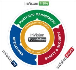
The 1.4 release of InVision software focuses primarily on new features and enhancements to InVision Foundation. InVision Foundation is the underlying platform that empowers:
- InVision InSite modules for facilities portfolio planning and management
- InVision FM modules for facilities operations, space analysis and asset management
- InVision Secure modules for risk analysis, and emergency planning and operations
Some of the new features in InVision Foundation include:
- New document linking tools: These link documents from any repository to data/features within InVision. Used with Microsoft SharePoint, InVision Foundation now has a specific interface to support SharePoint document linking.
- New geoprocessing task support: Use geoprocessing services to support business decisions, answering such questions as: How many customers are in the trade area associated with this store? How many competitors are within a 15-minute drive of selected locations? Does the selected service area qualify for government assistance?
- Enhanced search capabilities: Users can more easily find entities across the entire facilities portfolio. Configure the search tool to locate any entity with InVision, including addresses, buildings, assets and people.
- New red line markup capability: Users can report inaccuracies or gaps in facilities information and suggest ways to improve data. These red line suggestions can then be managed through a data quality improvement process.


